Deep Learning based Cyclone Intensity estimation using INSAT-3D IR imagery
Solution
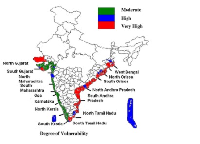
India currently has INSAT-3D Satellite that hovers on the Indian Ocean. Every year, 1000s of families and their homes are washed away because of the inaccurate prediction of forecasting and intensity of the cyclones. Since ISRO has given the challenge to predict the intensity of the upcoming cyclone of the future, given a satellite image captured by INSAT-3D, our model will use deep CNN and AlexNET to predict the intensity of the cyclone and the results can be used to mitigate the effects of the cyclone. AlexNET is a pre-defined model used for regression and classification problems of image datasets. Through this prediction we also aim to utilize the real time data from the images of the cyclones, that will be useful for the government.
Problem Statement
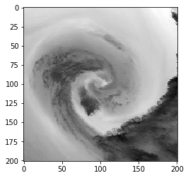
Development of a deep Convolutional Neural Network (CNN) for Tropical Cyclone intensity estimation using half-hourly INSAT-3D IR Images and development of a web application for visualization of the cyclonic images. INSAT3D/3DR observations are available at every 15-minute interval and these observations are very useful in understanding the instantaneous structural changes during evolution, intensification, and landfall of Tropical Cyclones. Datasets of Cyclones captured by INSAT-3D over the Indian Oceans are available since 2014. These datasets can be used for training and testing of the Model. Traditional methods for Intensity estimation require accurate center determination for intensity estimation. Development of CNN based model for intensity estimation will be very useful during the initial stage of cyclone formation when determination of accurate center becomes difficult.
Objective
- Use indian technology to predict real time intensity of cyclones along with the forecasting.
- To categorise the intensities of the cyclones in order to take the preventive measures and to generate real time data.
- Since ISRO has given the challenge to predict the intensity of the upcoming cyclone of the future, given a satellite image captured by INSAT-3D, our model will use deep CNN and AlexNET to predict the intensity of the cyclone and the results can be used to mitigate the effects of the cyclone. AlexNET is a pre-defined model used for regression and classification problems of image datasets
Through this prediction we also aim to utilize the real time data from the images of the cyclones, that will be useful for the government.